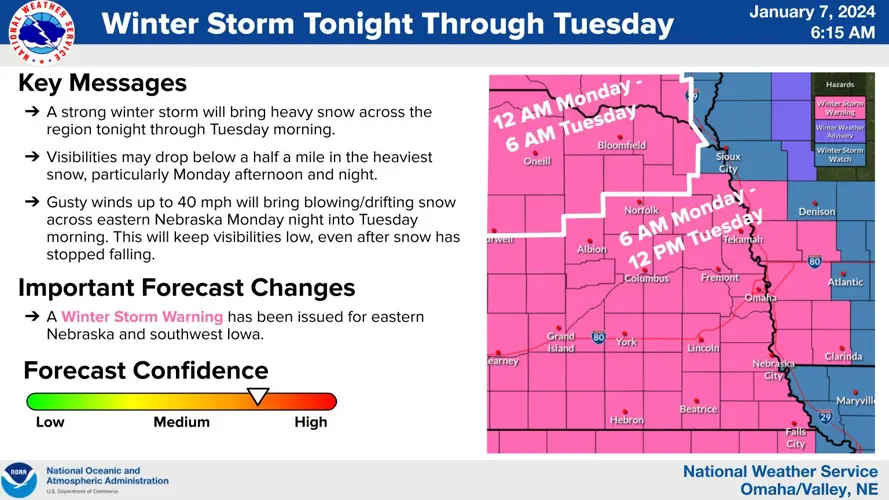
BEATRICE - It appears the eastern two-thirds of Nebraska and  parts of three other Midwestern states are about to get the first big blast of snowy weather, in the winter of 2024.

The National Weather Service upgraded a winter storm watch to a storm warning over the weekend.   For eastern Nebraska, the warning will be in effect from 6 a.m. Monday, through Noon on Tuesday.

Forecasters say heavy snow is expected, ranging from four to eight inches, driven by winds gusting as high as 35-miles-per-hour.  That will lead to drifting snow and difficult travel conditions…in some places, hazardous. 

The winter storm warning covers central, southeast and northeast Nebraska along with portions of southwest and west central Iowa.  It also includes several north central and northeast Kansas Counties, where wind gusts as high as 50-miles-per-hour are possible early Tuesday.

The Winter Storm Warning area stretches as far west as Lexington and Gothenburg….as far north as southern South Dakota.  The warning’s southern boundary includes Manhattan, Kansas, while the easternmost part of the warned area is around Shenandoah and Clarinda, Iowa.

Hazardous commuting is expected in many areas Monday and Tuesday mornings.  Forecasters encourage people who must travel, to have a flashlight, food and water in their vehicles in case of an emergency.  

The largest snow totals forecast with this storm are for southern and southeastern South Dakota…..where five to nine inch accumulations are expected.

Projected snowfall, by National Weather Serivce